Before And After Satellite Photos Show The Damage In Beirut After The Massive Explosion
When you think 2020 couldn’t get any worse with the Australian bushfires kicking off the year, then the coronavirus pandemic taking the torch, sprinkled with devastating floods in Indonesia, locust swarms in East Africa, and the Taal volcano eruption in the Philippines, there’s yet another tragedy that proves this year is the worst in quite a while.
On Tuesday, August 4th, a massive explosion shook the capital city of Lebanon, devastating several miles of cityscapes surrounding the epicenter of the blast. Over a hundred are reported dead with thousands injured and hundreds of thousands of people needing aid because of their homes being destroyed by the explosion and the subsequent shock wave.
A massive explosion shook Beirut, the capital city of Lebanon on Tuesday, August 2
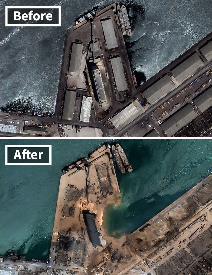
Image credits: European Space Imaging
The explosion occurred in a warehouse located at the city’s docks. Though it is not entirely clear what exactly caused the explosion, authorities claim that it’s quite likely that something went wrong in a fireworks storage unit that inevitably led to the ignition of a nearby 2,750-ton stockpile of highly explosive ammonium nitrate.
What entailed was a 0.24 kiloton explosion (according to early estimates) which equates to a low-yield nuclear explosion, roughly 60 times less than the bomb dropped in Hiroshima in 1945.
The explosion occurred in one of the warehouses located in the city’s docks
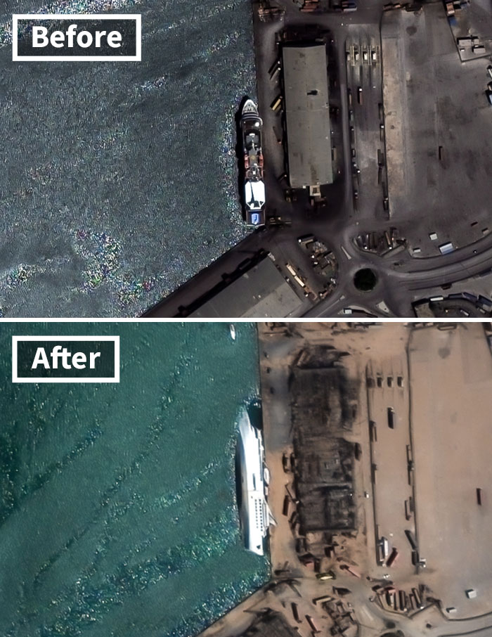
Image credits: European Space Imaging
If numbers don’t say much, then picture this: there’s a massive crater now in the place of the explosion that’s around 405 feet (or 123 meters) in diameter. That’s roughly 1.25 times the size of a football field.
Besides the crater, the buildings in its immediate surroundings were either leveled to the ground or left bareboned. The shock wave from the explosion left some of the residential buildings across the road from the docks greatly damaged with some having entire walls destroyed. Cars were flipped on their sides, if not on their roofs completely.
Since then, satellite imagery has been released showing how devastating the explosion was
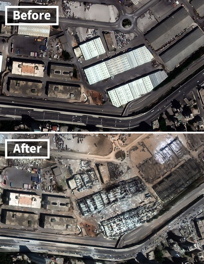
Image credits: European Space Imaging
There was even a relatively large vessel 1,500 feet away that turned on its side and capsized. In fact, the explosion was so big that it was picked up in Cyprus, 150 miles (around 240 kilometers) away, registering a seismic movement equivalent to a 3.3-point earthquake. That’s how big the explosion was.
A thorough investigation is currently being conducted with preliminary findings hinting at pure negligence. The inaction to do anything about the nearly 3,000 tons of confiscated ammonium nitrate years ago is what eventually led to this catastrophe.
Authorities suspect a fireworks warehouse and 2,750 tons of ammonium nitrate ignited, causing the explosion
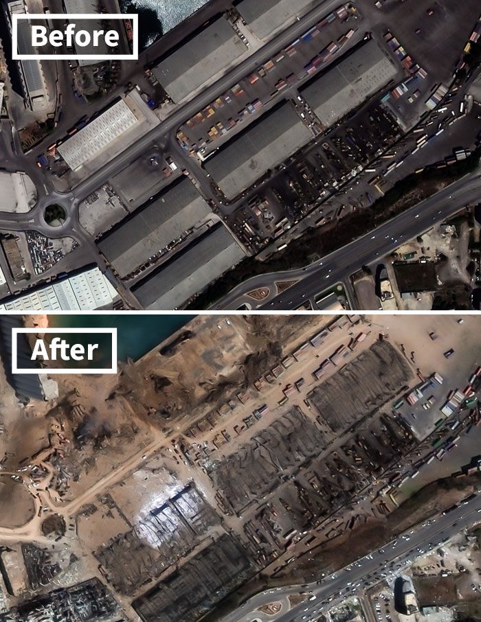
Image credits: European Space Imaging
Reports state that the death toll as of the moment of this article clocks in at 137 with over 5,000 injured and more than 300,000 displaced due to their homes being destroyed. Since the explosion, authorities have called for a two-week state of emergency and classified Beirut as a “disaster city”.
European Space Imaging has released a handful of satellite images of how things were before and after the explosion, showing how much damage the explosion has caused to the surroundings.
The explosion was so big that it left a 405-foot crater and capsized a ship not 1,500 feet away
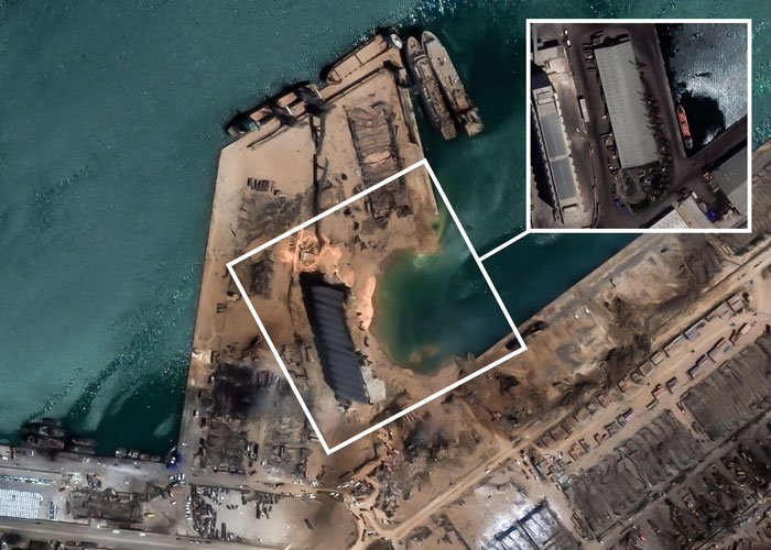
Image credits: European Space Imaging
“When disaster strikes, VHR satellite imagery can provide critical information for emergency relief operations to evaluate the extent of damage and get an entire overview of the scene,” explained the Managing Director of European Space Imaging, Adrian Zevenbergen. “It supplies crisis management teams with logistical insights for planning and helps to monitor and detect any changes that may be critical to minimizing or even eliminating further catastrophe.”
A number of countries have already sent out aid to Lebanon, including Turkey, Germany, and Russia with more joining the cause and organizing help.
Here’s a video comparing the various satellite images before and after the explosion
Image credits: The Globe and Mail
Pictures and videos of the aftermath came flooding on to the internet following the explosion, with this video of a senior citizen playing Auld Lang Syne on the piano amidst the wreckage in her house following the explosion, speaking volumes on how much it has affected the citizens of Beirut.
PlanetLabs and Maxar also shared their satellite images from the explosion
Videos like the one below flooded the internet soon after the explosion (viewer discretion is advised)
Image Credits: Raw Space
Another user managed to get some drone footage of the aftermath
A video of a senior citizen playing Auld Lang Syne in her devastated apartment has also popped up, summing up the scope and seriousness of the situation
What are your thoughts on this? Let us know in the comment section below.

 #livelovebeirut #livelovelebanon #prayforlebanon #prayforbeirut
Post Comment
No comments